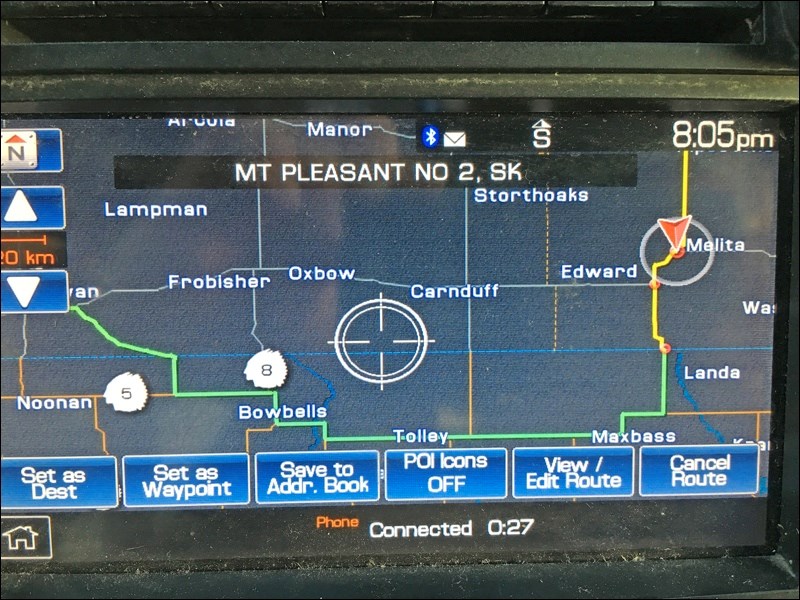
One of these days, number one daughter will return from summer camp and we will resume driver training. I think we’re getting to the point where we move from driving training to navigation, as in, we’re soon going to start doing some out of town trips of increasing length.
And this got me thinking, when or should I introduce GPS navigation? Or do we go old school, like when I, who am old, was in school, using a paper map? Do we start with the map?
I was thinking this over the long weekend as we made our way about Winnipeg and then from Steinbach to the cabin, and from the cabin to Estevan.
My 2011 Ford Expedition has an integrated GPS navigation system built into the dashboard. By 2011, one would think the technology was sufficiently mature. And perhaps a 2019 model, which I surely cannot afford, is mature. But my experiences over the weekend reinforced this one notion: “Do not trust your GPS. Take it under advisement only.”
First scenario: getting from hotel north of Polo Park out to Steinbach.
You would think, with major arteries like Portage Avenue running through the heart of Winnipeg, the navigation system would tell me to go south a couple blocks, get on Portage, and then onto the main drag leading out to Highway 1. You would think. But the navigation system did not think so. It instead directed me down an increasingly minor street until I was almost downtown, then some other side streets, before passing the Manitoba Legislature and then the train station and the way out. Okay, that wasn’t too bad.
Scenario 2: Steinbach to Sandy Lake
Leaving our friends’ place in Steinbach, for giggles I told the navigation system to plot our way to the cabin at Sandy Lake, an hour north of Brandon. This time, instead of telling me to hit the Winnipeg Perimeter Highway around the city, and thus avoid the city, it instead instructed me to pass right through the city centre, including down the very Portage Avenue I had wanted before. Thankfully, it was Sunday evening, there was little traffic, and I knew well enough to take the Perimeter, which I did.
But then we decided we wanted to take the TransCanada to Brandon, instead of turning onto the Yellowhead. For about 20 kilometres, the navigation system kept insisting we either turn around and go back to the Yellowhead turnoff, or turn down any north-bound road to go to the Yellowhead, instead of staying on the TransCanada.
Scenario 3: Virden to Estevan
There are roughly six ways to go from Virden to Estevan, and five of them are within just a few kilometres in length. Because I like to see what’s going on in the countryside in this area of the oilpatch, we routinely change it up and take different routes. But I would have never thought that crossing an international border, twice, and travelling through northern North Dakota would constitute a seventh.
Yet that was what the navigation system insisted we do. As we progressed south of Virden, it kept telling us to proceed south, across the U.S. border at Coulter, Man., to Renville, N.D. Then it wanted us to follow North Dakota Route 5 towards Lignite, then cross back into Canada at North Portal.
When I turned on Manitoba Highway 3 to Pierson (which becomes Saskatchewan Highway 18), the navigation system kept telling me to turn south, to cross the U.S. border. I should note that by this late in the evening, the border crossings were likely closed. If you followed its suggested route, you would get to a closed gate, at night. Once we crossed the Saskatchewan border, it finally recognized we were on a straight line route to Estevan, and told us to go straight.
I will say that the 2011 Ford Expedition’s navigation system is better than the 2008 Garmin GPS I used to use. If you loaded my aftermarket oil patch map, which included every gravel road in the patch, it would constantly tell you to take gravel roads to go anywhere instead of sticking to highways.
Alternatively, one could use the various maps apps in your phone. But this presupposes that you are in an area with sufficient cellular coverage. As I’ve squawked about in a never-ending fashion, I get better cell coverage in any southeast Saskatchewan pasture than I do in small town Manitoba or any of its highways, with the exception of those on Highway 1. And then there’s the whole issue of the legality of touching or holding a phone while driving, as in, big fine, no dice.
So where are we when it comes to teaching navigation? Maps, maps, maps. Learn the terrain. Learn to watch for signs and landmarks. Know which way you are going. Only after this is truly mastered can one ever really consider using a GPS. Even then, use it to figure out where you are, and beware of how it tells you where to go.
That’s just in case it tells you, “Turn left at the cow.”
���������ܱ����پ��Բ�.”
Brian Zinchuk is editor of Pipeline News. He can be reached at [email protected].��
��


