A preliminary spring runoff forecast isn't good news for the Humboldt region.
The Saskatchewan Watershed Authority (SWA) has prepared an early outlook of potential spring runoff conditions for the province based on a threat of spring flooding.
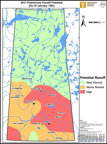
The outlook calls for the potential of high spring runoff across southern Saskatchewan, especially in the eastern part of the province. This is due to the excessive summer and fall rainfall across the agricultural portion of the province in 2010, combined with above-average snowfall to date.
The SWA puts together the forecast based on the amount of fall precipitation and the amount of snowfall received, explained Dwayne Rowlett with the SWA.
"The fall moisture in the northeast was, by far, the largest on record," Rowlett said. "The other factor, how much snow we have - the data is all over the place."
The snow water equivalent (the water equivalent of the snowpack) measurements from a satellite say that almost all of the grainbelt has 200 per cent of normal, Rowlett said. But, he added, the Environment Canada data is saying that the northeast has between 40 and 85 per cent of normal.
"Which data set do you believe?" he said. "Being on the ground, I believe it's somewhere in between. I think 200 per cent is too much and 40 to 75 per cent is too little."
Part of the problem, Rowlett said, is that the snowfall has been very variable, with pockets of heavier moisture scattered throughout the northeast region, including Humboldt, Melfort, Prince Albert, and Yorkton.
What he does believe is that the whole area was very wet heading into winter and people have to be prepared for the worst.
"It could be an average year or it could be what we saw in 2006 and 2007," Rowlett said.
What will eventually happen will depend a lot on how much more snow we get, he added.
"Up until the end of December, we get a lot of snow, but in January not so much," Rowlett explained. "February can be heavy and March is always a wild card. We can get lots of snow and rain or it can be dry."
Rowlett suggests that landowners may want to move bales, feed, and equipment out of any low-lying areas now, while everything is still frozen. For those who live near a large body of water, whether it's a slough or a small lake, they may want to start thinking about farmstead diking to protect their property.
Western portions of the agricultural area of the province went into freeze-up with adequate topsoil moisture conditions, while eastern portions had surplus topsoil moisture conditions, with rivers, creeks and lakes entering the fall freeze-up period at very high levels relative to seasonal normals.
Unfavourable weather conditions in the future, such as above normal precipitation and/or rapid snow melt will increase the threat of flooding. Even with average weather conditions between now and runoff, the SWA expects some flooding to occur. Below normal precipitation and/or a slow snow melt will help alleviate the threat of flooding.
The preliminary runoff outlook is based on soil moisture conditions at freeze-up and existing snowpack accumulations as of mid-January 2011. The outlook assumes average climatic conditions will occur through to the end of spring runoff.
The forecast is based on limited data and should only be used as a general guide for large areas, as local conditions may vary the SWA warned.
The SWA will prepare more detailed forecasts in early February, March, and April.


