REGINA — While in some areas of Saskatchewan, runoff is merely a faraway dream, the Water Security Agency (WSA) has released the Spring Runoff Report for 2023.
The information gathered in this report is based on conditions as they were on March 1.
Moisture conditions across southern Saskatchewan were generally dry at freeze-up in 2022, particularly on the west side of the province where drought conditions were prevalent.
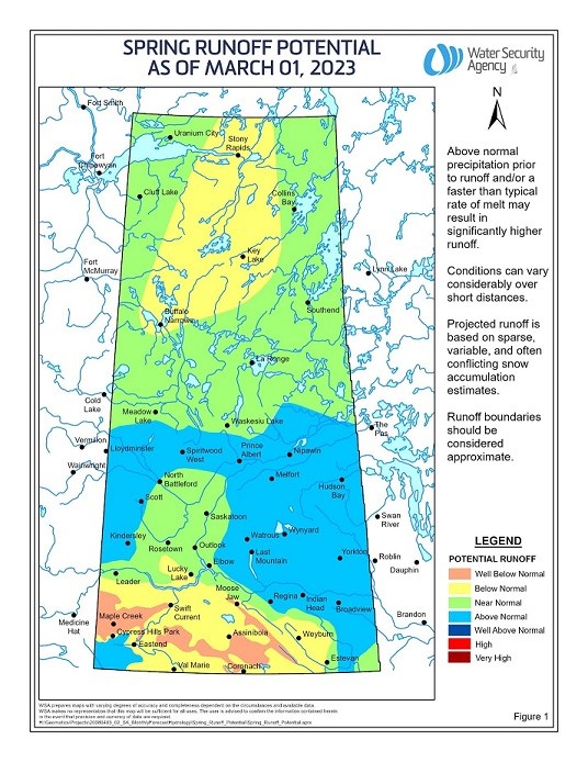
Winter snowfall has ranged from below normal over much of southwestern Saskatchewan (other than a small pocket in the extreme southwest south of the Cypress Hills where the snowpack is well above normal), to well above normal through much of central Saskatchewan.
The agency does not anticipate flooding even in areas where above normal runoff is expected, assuming near-normal conditions as spring progresses.
Warmer than seasonal temperatures resulted in the near complete melt of the snowpack over a large area of southern Saskatchewan, including areas north of the Cypress Hills and much of the Old Wives Lake Watershed. With variable moisture conditions at freeze-up, mid-winter melts and a variable snowpack, the runoff potential for the province also differs significantly.
In the north, near-normal snowmelt runoff is generally expected, other than an area from Stoney Rapids down toward Buffalo Narrows where below-normal snowmelt runoff is predicted.
In the south, above-normal snowmelt runoff is expected in a band extending from Lloydminster east to the border, due to well above-normal snowpack. Below to well below normal snowmelt runoff is expected over much of southwest and southcentral Saskatchewan. The exception is south of the Cypress Hills where, with a heavy snowpack, above-normal snowmelt runoff is expected.
The WSA says it is important to note this forecast is based on conditions as of March 1. Above-normal snowfall over the next month could still produce near-normal runoff over areas where below or well below normal snowmelt runoff is expected, particularly if it melts quickly.
In areas where below or well below normal snowmelt runoff is expected, some water supply concerns may emerge or intensify, warns the WSA. For instance, irrigation water supply in the Bigstick Lake Basin near Maple Creek is expected to experience a third consecutive year of shortages.
The difference between the preliminary runoff map issued in early February and the current map is the inclusion of data from late-February snow surveys, measuring snowpack water content. With the benefit of the snow survey information, there is much higher confidence in the current runoff potential outlook, the WAS reports.
WSA monitors conditions throughout the spring melt and provides updates as situations develop. The next spring runoff forecast will be issued in early April, available on .


